| このページは、2019年3月に保存されたアーカイブです。最新の内容ではない場合がありますのでご注意ください |
The Son La Hydropower Project is the largest hydropower development scheme in Vietnam currently under construction. It is located approximately 250 km northwest of Hanoi, and about 190 km upstream of the existing Hoa Binh Hydropower Project on the Da River which is the largest tributary of the Red River. The Red River originates in the mountainous areas of Yunnan, China.
The Red River is formed by the confluence of three rivers: the Thao, the Da, and the Lo. The flow of the three rivers is characterized by tropical monsoon rains and coincides with high summer floods on these rivers sometimes resulting in disastrous flooding of the Bakbo plain around the Red River delta where Hanoi, the capital of Vietnam having more than 2.7 million inhabitants, is situated. Consequently, the flood control of the Red River in the wet season is one of the main goals of the Project. The flood control volume of the Son La reservoir and the Hoa Binh reservoir is 7.0 billion m3 in total.
Once the Son La Project is put in operation, the flow will be firmed up and the base flow will be stabilized. This will significantly improve the downstream flow regime in the dry season. The achievement of improved water supply in the dry season for the Red River delta is also one of the main goals of the Project. Namely, the full supply level (FSL) at El. 215m of the Son La reservoir having an active storage capacity of 5.97 billion m3 gives an option for downstream water supply in the dry season for the Red River delta.
Salient Features of Son La HPP are as tabulated below.
| No. | Descriptions | Particulars | Data |
| 1 | Hydrogy | Catchment Area | 43,760 km2 |
| Mean Flow | 1,532 m3/s | ||
| Peak Flood Flow(P=0.1%) | 28,600 m3/s | ||
| 2 | Reservoir | Propbable Max. Flood Level | EL. 228.07 m (PMF) |
| Surcharge Level | EL. 217.83 m (modified P=0.01%) | ||
| Full Supply Level | EL. 215.0 m | ||
| FWL (flood waiting level) | EL. 194.08 m | ||
| Min. Operation level | EL. 175.0 m | ||
| Full Capacity | 9260x106 m3 | ||
| Effective Storage | 6504x106 m3 | ||
| Flood Preventive Storage | 4000x106 m3 | ||
| 3 | Dam | Type | Gravity Concrete (RCC + CVC) |
| Crest Evelvation | EL. 228.1 m | ||
| Max. Height | 138.1 m | ||
| Crest Length | 962 m | ||
| 4 | Spillway | Probable Food Discharge | 38,240 m3/s (P=0.1% PMF) |
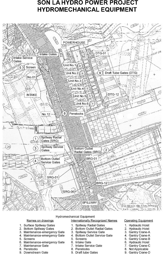
| Bottom Outlet | 12 nos. x (6.0mW x 9.6 mH) orifice, Sill level EL. 145.0m Radial Gates with Hydraulic Hoists | ||
| Surface Spillway | 6 nos. x (15.0mW x 11.46mH) orifice, Ogee crest level EL. 197.8m Radial Gates with Hydraulic Hoists | ||
| Spillway dam height | 93.1 m | ||
| Transverse joint spacing | 38.5 m | ||
| Chute channel | Symmetrically flared open channel with terminal flip bucket | ||
| 5 | Intake | Type | Bell-mouth inlet with vertical removable trash rack |
| Centre line level | EL. 156.0m | ||
| Quantities | 6 nos. each for one generating unit | ||
| Inlet spacing (c to c) | 31.5 m | ||
| Dam joint spacing | 31.5 m | ||
| Trash rack for each inlet | 2 sets x (11.5mW x 31.5mH) | ||
| Penstock | 6 Lanes, Diameter 10.5 m | ||
| 6 | Powerhouse | Generation capacity | 6 x 400 MW = 2,400 MW |
| Design discharge | 6 x 573 m3/s = 3,438 m3/s | ||
| Rated net head | 78.0 m | ||
| Unit spacing | 31.5 m | ||
| Concrete joint spacing | 31.5 m | ||
| Bottom of draft tube | EL. 81.0 m | ||
| Turbine distributor centre | EL. 105.0 m | ||
| Powerhouse yard ground | EL. 138.0 m | ||
| Type of Turbine | Vertical Shaft Francis | ||
| Speed | 90.0 rpm | ||
| Max. tail water level | EL. 136.95 m (PMF) | ||
| Tail bay | Open channel with upward bottom slope (1:3) | ||
| 7 | Diversion system | Channel | 90 m wide open channel with bottom level of El.110m Double box culvert (2 x 12m W x 13m H) |
This project is located at cordinate of N 21o30', E 104o00'. You may not googling the map. Only you can find a areal photo before construction.
Longitudinal section of spillway and intake/powerhouse at flow direction is here. General Plan is here .
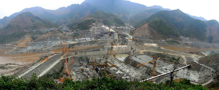
Photo below show the general view of the project on April 29, 2008 from the left bank side. Da river flows left to right in the photo.
Intake and powerhouse are located at the left bank side. Spillway is located at right bank side.
The dam is constructed in RCC (Roller Compacted Concrete). You can see several lanes of belt conveyor systems for transporting concrete for RCC.
General View on April 29, 2008from Left Bank

General View from Downstream (May 11, 2008)
| To top Page | Next page |
2008-05-07 Created
2008-05-11 Added photo from downstream and corrections
![]()
| このページは、2019年3月に保存されたアーカイブです。最新の内容ではない場合がありますのでご注意ください |